Release of Quasi-Real-Time Snow Depth Map: National/Regional Versions
December 22, 2020
Research Institute for Natural Hazards & Disaster Recovery, Niigata University has jointly published a Quasi-Real-Time Snow Depth Map since 2012 in collaboration with the Graduate School of Engineering, Kyoto University. The 2020/21 winter version has been published since December 15.
The Quasi-Real-Time Snow Depth Map offers information to visually understand the snow depth of as a spread area. On this site, in addition to the daily snow distribution status of all over Japan observed at nine o'clock, created by the Quasi-Real-Time Snow Depth Monitoring System, the distribution map of the differences in snow depth from the previous day is posted in near real time.
Detailed snow depth distribution maps by region for Hokkaido, Akita, Niigata and Tottori Prefectures are also available to support regional winter disaster prevention.
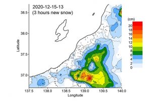
Furthermore, given the human damage as well as the large-scale traffic obstacles resulting in vehicles being stranded long-term on roads and railroads due to sudden heavy snows in recent years, we have been publishing a snowfall distribution map for national, Niigata Prefecture and Tottori Prefecture versions at regular time intervals of one, three and six hours, using the hourly snow depth data since 2016, in order to understand the intensive heavy snow in detail.
Click the link below to see the map.
Quasi-Real-Time Snow Depth Map (National/Regional version)